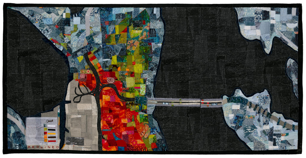
Cotton, silk organza, and polyester fabrics, photo transfer, cotton thread and found objects on wool, 72" x 36"
This fabric collage map of Seattle, WA and surrounding suburbs was inspired by The Racial Dot Map, a project of the Weldon Cooper Center for Public Service. The Racial Dot Map used 2010 census data to plot one color coded dot per person on a map of the United States. Different colored dots represent different racial groups; light blue represents white, green represents black, red represents Asian, yellow represents Hispanic/Latino, and brown represents “other race/Native American/multi-racial”. Included in this catchall category are the Suquamish, Duwamish, Nisqually, Snoqualmie, Muckleshoot, and other descendants of indigenous peoples displaced by white settlers—people whose communities and ways of life are so disrupted that they scarcely show up on the Racial Dot Map in Seattle at all.
The resulting map is beautiful. But it also tells an unsettling national story about race in stark visual terms.
Though the Racial Dot Map uses 2010 census data, it almost perfectly corresponds with 1937 Federal Housing Authority ‘Redlining Maps’. FHA Maps used redlines to demarcate non-white from white neighborhoods—or in the terms of the day—‘detrimental influences’ and ‘infiltration of lower grade population’ vs. ‘still good’ and ‘homogenous’. In most American cities, black neighborhoods were the first to be redlined. In Seattle, Japanese neighborhoods were the initial focus of redlining. This localized phenomenon reflects not only anti-black sentiment in the Pacific Northwest Territory prior to statehood, but also wider West Coast xenophobia directed towards Asians and Asian Americans.
Seattle did not experience significant Black in migration until WWII related jobs helped spur the Great Migration of African Americans from the American South. With Executive Order 9066 which forced Japanese and Japanese Americans to relocate to concentration camps, African American migrants settled into Seattle neighborhoods and White land owners reclaimed land previously leased to Japanese farmers. Japanese farmers had developed this land into highly productive agricultural land. With the removal of the Japanese, White Americans rushed to transform highly productive agricultural land into even more lucrative suburbs, eventually lobbying to replace ferry service with bridges.
FHA redlining maps codified historical patterns into the landscape for future generations. Map makers working for the federal government created artificial boundaries that would be reinforced by mortgage brokers, real estate developers, and real estate agents in their day to day business practices, to construct deeply segregated cities and suburbs. These maps created and separated ‘good’ neighborhood from ‘bad’ in order to maintain social, political and economic separation characteristic of the Jim Crow era. Legal barriers to interracial marriage and interracial sharing of societal wealth and resources became enshrined in spatial barriers to effectively disrupt political common cause across racial lines. In other words, maps reinforced social, economic and political separation and by doing so, nearly guaranteed unlimited extraction, privatization and commodification of people, land and resources.
Meanwhile, ‘urban redevelopment’ that followed carved up the heart of multiracial cities across the country while simultaneously easing the way for ‘white flight’ out of the city. Communities of ‘Others’ now cluster amongst the winding branches of the freeway in neighborhoods ‘redeveloped’ by removal. And those same freeways, like rivers, carry suburban commuters into and out of the city for work, while their wealth is hoarded in exclusive, homogeneous, and uniform suburbs.
As I recreated the racial dot map in fabric, I began to see how consolidating and containing the “Other”—be it the racial, immigrant, artist or gender non-conforming Other—concentrates creativity and resilience into the center of the city, creating the vibrant heart of the city. Though residents are all too often segregated from wealth and opportunity, the creativity that the city requires and generates makes it alive. The otherness of the city is the foil that makes whiteness. It is where people live to escape the oppressive passivity that extreme privatization and commodification of life and property demands.
